The MD of Bonnyville is mapping out the future of their roads.
The municipality passed their road classification map during their Sept. 11 council meeting.
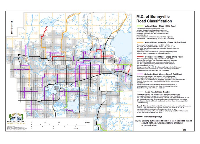
“What this is, is a guide map. This classifies these roads, and then when the time comes to upgrade these roads, they will be upgraded based on their classification,” explained Abid Malik, general manager of infrastructure services for the MD. “We’ve also included that the existing level of the roads shouldn’t be downgraded, so there’s nothing to worry about with those roads.”
The map has been in the works for some time, and defines MD roadways based on a multi-level classification system.
Class one consists of arterial roads that carry typically over 1,500 vehicles per day.
These roads have moderate to high truck traffic, and provide direct connection to a provincial highway, or other class one or two.
Those that fall under this classification, such as Range Rd. 450, have a 10-metre top width pavement surface of mix asphalt concrete and a 40-metre right-of-way.
A road that carries over 2,000 vehicles per day falls under the arterial road industrial class one A grouping. They have moderate truck traffic, a top width of 11.5-metres of pavement surface with hot mix asphalt concrete, and a 40-metre right-of-way. Some of the roads that fall under this classification are Range Rd. 462, 420, and 485.
Major collector roads, or roadways that carry between 200 to 1,500 vehicles every day, have moderate truck traffic.
Roads such as Twp. Rd 622, 634, and portions of Range Rd. 475 require a nine-metre top width of pavement surface made of hot mix asphalt concrete and a standard right-of-way of no less than 30-metres. These roads don’t always connect to a provincial highway, however, they do join up with a class one, two, three, or four route.
The minor collector roads, also known as class three, have a low amount of truck traffic and roughly 200 to 500 vehicles travel them per day. Twp. Rd. 630, 624, Range Rd. 475, 443, and 624 are among the ones that fall under this category.
The eight-metre top width pavement made of cold or hot mix asphalt concrete must have a right-of-way of more than 20-metres. While they don’t provide direct access to any highways owned by the province, they could link up with one of the MD’s various roadways.
Roads with less than 200 vehicles per day are called class four or five, which is known as local roads.
In class four, there’s generally less than 200 vehicles travelling that way every day, and there’s a low proportion of truck traffic. With an eight-metre top width made of gravel, this category generally has a right-of-way of 20-metres.
Class five roads are meant for low volume, low speed traffic. They tend to have a six to seven-metre gravel surface and a 20-metre right-of-way. On these roads, there tend to be three or less serviced residences. A seven-metre top width roadway is generally used for areas that see 25 vehicles or less in a day.
CAO Luc Mercier said, “What administration will do with this, is take council’s direction after the approval of this map, to come up with a long-term capital replacement plan for our infrastructure as well as develop our long-term maintenance plan for our roads, because different types of construction are needed for these roads. That will form the foundation of how we come up with numbers, because we’re going to show you a 20-year capital replacement plan for the roads so you can better gauge your budgets going forward.”
Reeve Greg Sawchuk noted having a physical plan in place can give the MD a leg up during discussions with other municipalities.
“What this long-term plan does… as we go into talks with our urbans and we’re saying what our costs to run the MD are, we can put this out there and say that in 10 years we’re looking at having to rebuild these roads and the cost to the MD is going to be huge,” he explained. “To make them more aware with having this planning document in place, it gives us that ammunition, we’re not just spouting off words.”
Although the map could change over time, Coun. Marc Jubinville was pleased with the idea.
“I think the whole thing makes sense and it’s a plan that’s needed. It gives direction and it makes sense.”


